Friday, December 30, 2016

Et tu, King County Library System?


Whenever I'm shopping for a used book, I look for ex-library copies. They usually arrive in decent shape, encased in a nifty mylar dust jacket. Occasionally, the margins contain the amusing or even insightful scribbles of some discourteous library patron. So, I had mixed feelings when I recently found an ex-library copy of Richmond Must Fall offered for sale online. The price was decent and, in a few minutes, the book was in my cart and on its way to my house. It arrived at my doorstep with the words "King County Library System, WA" stamped prominently across the top edge.

I'm no library expert, but I figure books get the boot when they gather too much dust on the shelves. However, this copy has a few signs of life: small coffee stains on the fore edge and a less than tight spine. Western Washington is one of my favorite places. So I felt a little deflated that the good people of King County had demonstrated little appetite for a detailed, tactical study of Grant's sixth offensive at Petersburg - what's wrong with them? However, my faith rebounded and my spirits rose when I checked the King County online catalog and found three copies still circulating in their system. I am happy to take this fourth copy off their hands. Besides, the mylar is nice and shiny.  

Saturday, December 10, 2016

Petersburg National Battlefield Expansion


https://www.nps.gov/common/uploads/photogallery/ner/park/pete/1DD1F79C-155D-451F-67164822A260A8C0/1DD1F79C-155D-451F-67164822A260A8C0.JPG
Petersburg National Battlefield - Fort Stedman (Source: National Park Service)

Boundary Expansion (Source: docs.house.gov)
On December 8, 2016, Congress passed legislation to significantly expand the Petersburg National Battlefield. This is big news, at least for those interested in the Petersburg Campaign. The bill authorizes the National Park Service to add more than 7,000 acres to the park's land. The Civil War Trust, which has done much to preserve land around Petersburg and elsewhere, released a detailed announcement. The new land includes parcels at Peebles' Farm, Five Forks, Reams Station, and the White Oak Road among many other locations. It also appears the expansion may include a part of the Burgess Farm along the Boydton Plank Road - the fields where the Burgess family barns stood and Brigadier General Thomas Egan deployed his division during the battle on October 27, 1864. I recently posted a little-known map of this area from the National Archives.  


Thursday, October 27, 2016

From the National Archives: Burgess Mill Map

Map of the Battle of Burgess Mill, Oct. 27, 1864
Horace P. Rugg Court-Martial Transcript, 95–100, Record Group 153 (LL-649), NARA.

When I filled out the "pull slip" for Horace P. Rugg's court-martial file at the National Archives several years ago, I had low expectations. Too often, these folders end up being stuffed with disappointment. This one, however, proved to be a gold mine. The container bulged with a stack of folio-sized paper bound with a knotted pink ribbon. There was little sign it had been examined before, save for one reader sometime in the late 19th century.

Map Accompanying Hancock Report (O.R.)
October 27, 1864 was a bad day for Horace Rugg, a Lieutenant Colonel from New York who commanded a brigade in Winfield Hancock's Second Corps. Hancock's force represented the business end of a large-scale offensive to capture the South Side Railroad and bring Confederate Petersburg to its knees. By the afternoon, however, Hancock and and his men found themselves isolated on a remote Dinwiddie County farm miles from the Union lines and pressed on three sides by Confederate troops.  The offensive had stalled and Hancock prepared to march his men back to the safety of the Union lines. Before any such movement began, however, a slashing Confederate attack, a three-brigade column led by William Mahone, hit Hancock's unprotected right flank.

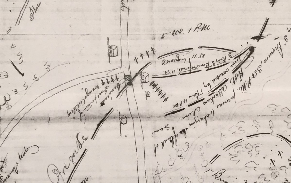
As the Confederate assault split the Second Corps in half, Horace Rugg froze in his tracks and failed to carry out orders relayed to him by one of Hancock's aides. The Second Corps survived the afternoon. However, in a few days, Rugg found himself immersed in a court-martial proceeding at the Globe Tavern south of Petersburg. The results of the tribunal put Rugg out of a job and out of the army. During the hearing, a clerk penned a lengthy transcript, which eventually made its way into that ribbon-bound folder in the National Archives. At the end of these sheets, I found this map (at the top of this post). It shows the movements of various units under Hancock's command and pinpoints the positions of Union forces, as well as some Confederate units, during the battle.  It bears some resemblance to the map attached to Hancock's report in the Official Records (right). O.R. 42(1):233.

In Richmond Must Fall (Kent State Univ. Press, 2013), I wrote a detailed account of this battle using this map and other sources to guide the narrative. It was a complicated fight, ending in that audacious Confederate attack. On the anniversary of the battle, I'm happy to share this interesting sketch, which, to my knowledge, has never been published before. Here are some of the map's details.

 Map Detail:  Burgess Mill and Hatcher's Run

Burgess Mill on the Boydton Plank Road
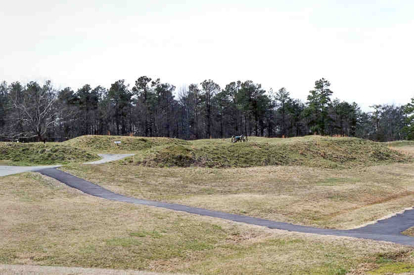
This section of the map shows the Burgess Mill pond to the left of the Hatcher's Run bridge. The mill itself can be seen on the north bank of the Run, next to the bridge and the dam. The top left corner depicts some of the rebel batteries that peppered Hancock's position throughout the day. South of Hatcher's Run, the map displays the location of "rebel entrenchments." Several accounts mention these works, which had been dug by Confederate forces stationed at this location. This trench line was oddly sighted. It sat several yards south of Hatcher's Run and faced away from the stream. The map also notes that Brig. Gen. Thomas A. Smyth's brigade captured the position at 1:30 p.m. that afternoon.  

Map Detail:  Burgess Tavern

Intersection of the Boydton Plank & White Oak Roads
The Burgess Tavern appears here at the northwest side of the Boydton Plank Road and White Oak Road intersection. The Burgess homestead can be seen to the south and just west of the Plank Road. The two structures on the east side of the road (one large and one small) depict barns belonging to the Burgess family. The hatched band stretching across the Boydton Plank Road represents a tollgate, which had been converted by Confederate soldiers into a barricade.

Map Detail:  Hancock's Field Headquarters

Intersection of Boydton Plank & Dabney Mill Roads
Winfield Hancock's field headquarters, marked at the intersection with the trefoil (the Second Corps' symbol), was located beside a massive oak tree (not shown here). During the afternoon, Generals Grant and Meade, as well as their staffs, arrived on the field and gathered at the spot to consult with Hancock.  Over the course of the afternoon, the group came under fire from Confederate batteries in the distance. During one moment of crisis, General Grant sat on a rock near the oak, calmly enjoying a cigar. A shell screamed through the sky, exploding in the tree top overhead. The General seemed unperturbed and continued to puff leisurely.  

Map Detail:  William Mahone's Attack


Mahone launched his assault late in the afternoon - at 3:45 p.m. according to this map. Approaching along a wood road, he formed a two-brigade front with the fourteen hundred men of William MacRae’s North Carolinians on the right and the Virginia brigade, about a thousand men, on the left. Deployed two rows deep, this battle line probably stretched for more than 2,000 feet. Mahone also massed the Alabama brigade, an additional thousand rifles, in column of regiments behind the front line. He spread a skirmish line on his left flank, using sharpshooters who positioned themselves at twenty-foot intervals. As the Virginians and Tarheels dressed to the colors, Mahone rode along the ranks encouraging his men, urging them to hold their fire and rely on the bayonet. “In a minute or two we were ordered forward,” recalled George Bernard in the 12th Virginia, “and came immediately upon the enemy’s line of skirmishers, who were in the woods not a hundred feet in front of us.”

Monday, October 10, 2016

Whiskey Time


Wading through some regimental books recently at the National Archives, I found this random nugget bobbing amid some mind-numbing minutiae:

Record Group 94, Regimental Books, National Archives.

"Officers of this Regiment who feel the necessity of getting drunk will notify the Adjt and he will designate a suitable time, but not on a march or move. By command of Col Geo W Cole, Comdg Regt."  

          This amusing document aside, George W. Cole, a New York physician, provided extensive service to the Union cause during the war.  He fought at First Bull Run and served throughout the conflict in several different regiments, suffering a serious leg wound in 1862.  The next year he was instrumental in raising the 2nd U.S. Colored Cavalry at Fort Monroe,Virginia.  He led the unit, whose officer's apparently enjoyed their drink, through to the war's end.  In 1867, he killed a man who had been involved in an affair with his wife.  Charged with murder, Cole was acquitted.  He died in New Mexico in 1875. 

Saturday, September 17, 2016

The Battle of Antietam, September 17, 1862: Bolstering the Confederate Left

"The battle of Antietam or Sharpsburg" by Edwin Forbes, Library of Congress

          On a September night in 1894, John T. Parham, a veteran of the 32nd Virginia Infantry, addressed the A.P. Hill Camp of Confederate Veterans in Petersburg and described his experiences during the Maryland Campaign thirty-two years earlier. In 2004, a transcription of Parham’s address appeared in a batch of papers discovered in Roanoke and was later published in Civil War Talks: Further Reminiscences of George S. Bernard and His Fellow Veterans.
          Below is an excerpt from Parham's account. As the Confederate left faltered on the morning of September 17th, Parham’s brigade rushed to the battlefield on the heels of a grueling night march from Harper’s Ferry. As they approached the fighting in the West Woods near Dunker Church, they were greeted by Stonewall Jackson:

          When we got within a half mile of the field of battle, Gen. Stonewall Jackson, who was within a few yards of our regiment, had the command halted, and by his order we got in light fighting trim, unloading our luggage (haversacks and canteens excepted). We then moved forward at a double-quick, marching by the right flank across fields, creeks, woods, stone-walls, and often fences. Gen. Jackson riding along with us and [seeming] by his manner impatient for our division to reach Gen. Early as soon as possible. I well remember his appearances as he rode on with us, some time ahead of us, mounted on his little sorrel, leaping fences, fording streams and jumping ditches. Gen. McLaws, our division commander, fearful that our rapid marching would break the men down before we reached the field of action, ordered us to march at quick time instead of at a double-quick, and so slackened our gait a little. I presumed by leave of Gen. Jackson. But Gen Jackson soon had us on the trot again.
           We soon reached the field of battle. Barksdale’s brigade of our division went in front forming a line of battle to our right and moving forward before our brigade formed its line of battle. It was a magnificent sight--this brigade charging across the field in its front to the woods beyond, facing as they advanced a storm of shot and shell, together with a hot infantry fire. The line faltered not at all, but pressed steadily forward.

http://hamptonnewsome.blogspot.com/p/civil-war-talks.html
          - John T. Parham, 32nd Virginia, “Reminiscences of the Maryland Campaign of 1862,” published in Civil War Talks: Further Reminiscences of George S. Bernard and His Fellow Veterans, University of Virginia Press, 2012.  Original in the Bernard Collection at the Historical Society of Western Virginia.


Monday, May 30, 2016

USGS Historical Topographic Map Explorer


Gettysburg, Pa. results from the USGS Historical Topographic Map Explorer


Here is a nice resource for tackling pesky topographic puzzles:  the Historical Topographic Map Explorer, a convenient tool provided by the U.S. Geological Survey (USGS).  The available quadrangles reach back as far as the 1880's. Though these old maps postdate the Civil War by a few decades, I've found them useful in pursuing questions about 19th century road networks and terrain.  In the past though, the vintage surveys have been difficult or impossible to locate online. This tool, launched in 2014, now makes it easy to find all available maps with just a few clicks. Its usability is excellent.  Just search for the location you need, click a city name on the modern map, and the site automatically generates a timeline of all the available maps for the area that you can view and download.  I've included a screen shot for a search of "Gettysburg" at the top of this post.  Here are a few more images from the site:

New Bern, N.C. (USGS, 1901)


Petersburg, Va. (USGS, 1894)


Fredericksburg, Va. (USGS, 1889)

Upcoming Talks

Things were busy this year. I had the opportunity to give about a dozen talks and several online interviews.  It was fun to visit many inter...